


INDIA is a developing country with limited financial resources. The country is striving to provide basic amenities to its growing population. Climate change, a global problem, further adds to its already growing developmental challenges. Majority of the country’s production/economic sectors are vulnerable to the impacts of climate variability and change.
This article presents an overview of the recent evidence of the impacts of climate change in India. The article starts with a general discussion on climate change including observations and projections cited in recent IPCC reports and national reports. Thereafter the discussion moves on to the observed impacts in the identified key sectors of national significance namely, Himalayas and Glaciers, Water re-sources, Agriculture, Forests, Marine and Coastal ecosystems. These sectors reasonably represent the major sectors that face the impacts of climate change due to inherent vulnerability. Figure 1 shows the relationship of these climate-sensitive sectors and the ‘worst-hit’ groups. These groups have high exposure to the worst impacts of changing climate as they are dependent on the climate-sensitive sectors for their livelihood, food and shelter. These groups also have the low adaptive capacity that makes them vulnerable to the risks posed.

Climate change and its impacts
A greenhouse maintains temperature conditions optimum for the growth of plants. Similarly, the planet earth also has a natural green-house cover made of certain gases known as Greenhouse gases (such as CO2, CH4 , N2O, H2O) which maintain temperature conditions optimum for the sustenance of life on earth. Continued and overwhelming emission of greenhouse gases due to human activities causes additional warming and long-term changes in the components of the climate system, increasing the possibility of severe, widespread and irrevocable impacts on society and ecosystems.
United Nations Framework Convention on Climate Change (UNFCCC) defines Climate Change as “Change in Climate attributed directly or indirectly to human activity that alters the composition of global atmosphere and is in addition to natural climate variability over comparable time periods.”
Due to its varying physical features, diverse socio- economic profile and a wide range of climatic conditions India is vulnerable to the impacts of climate change. Out of India’s 36 States and Union Territories in the country, 27 are disaster prone. Around 12 per cent land is prone to flood and river erosion, of the around 7,500 km coastline, 5,700 km is prone to cyclones; 68 per cent of the cultivable land is vulnerable to drought; hilly areas are at risk from landslides and avalanches; and 15 per cent of the landmass is prone to landslides
To assess scientific, technical and socio-economic information concerning climate change, its potential effects and options for adaptation and mitigation, World Meteorological Organization (WMO) and the United Nations Environment Programme (UNEP) jointly established the Intergovernmental Panel on Climate Change (IPCC) in 1988. The IPCC assesses research on climate change and synthesizes it into ‘assessment reports’ every 5–7 years. The latest in the series of such reports are the volumes of the Fifth Assessment Report (AR5) of IPCC released in 2013 and 2014. The Special Report on ‘the impacts of global warming of 1.5°C above preindustrial levels and related global greenhouse gas emission pathways, in the context of strengthening the global response to the threat of climate change, sustainable development, and efforts to eradicate poverty’, is the first publication in the Sixth Assessment Report (AR6) cycle of IPCC. Key highlights from IPCC SR 1.5 are given in the following bullets:
- Average global temperature has increased by about 1.0°C as compared to pre-industrial levels due to anthropogenic actions. Extreme weather events have increased, both in severity and in occurrence
- The effects of temperature rise on people and ecosystems at 1.5°C are much greater than previous scientific reports originally expected
- The overall impact at 2°C is well above 1.5°C and will be disastrous for the developing countries
- The Paris Agreement’s objective of limiting temperature increase to 2°C needs to be reviewed. The target now needs to be strongly set at 1.5°C for a safer world
- To remain under 1.5°C temperature rise, the world will have to reduce CO2 emissions by 45 per cent from 2010 levels by 2030 and attain net zero emissions by 2050
- Even with a warming of 1.2°C, which is slightly higher than the annual global average, India is severely impacted. The impact at 1.5°C would increase significantly and be devastating for farmers and coastal communities at 2°C
- The report highlights a number of climate change impacts that could be avoided by limiting global warming to 1.5°C compared to 2°C, or more. For instance, by 2100, global sea level rise would be 10 cm lower with global warming of 1.5°C compared with 2°C. The like-lihood of an Arctic Ocean free of sea ice in summer would be once per century with global warming of 1.5°C, compared with at least once per decade with 2°C. Coral reefs would decline by 70-90 per cent with global warming of 1.5°C, whereas virtually all (> 99 per cent) would be lost with 2°C
- The report finds that restricting an unnatural weather change to 1.5°C would require “quick and expansive” advances in land, vitality, industry, structures, transport, and urban communities. Worldwide net human- caused emanations of carbon dioxide (CO ) would need to fall by around 45 per cent from 2010 dimensions by 2030, achieving ‘net zero’ around 2050. This implies any residual outflows should be adjusted by expelling CO from the air.

How impacts are placed in negotiations
The Convention sets an ultimate objective of stabilizing atmospheric concentrations of greenhouse gases at a level that prevents dangerous anthropogenic interference with the climate system. Such levels, which the Convention does not quantify, should be achieved within a time frame sufficient to allow ecosystems to adapt naturally to climate change, to ensure that food production is not threatened and to en-able economic development to proceed sustainably. To achieve this objective, all countries have a general commitment to address climate change, adapt to its effects, and report on the action they are taking to implement the Convention.
As per Article 3.1 of the Convention: “The Parties should protect the climate system for the benefit of present and future generations of humankind, on the basis of equity and in accordance with their common but differentiated responsibilities and respective capabilities. Accordingly, the developed country Parties should take the lead in combating climate change and the adverse effects thereof.”
Warsaw International Mechanism (WIM) on Loss and Damage
The mechanism was established at the COP19 in Warsaw, Poland. It addresses losses and damages associated with the impacts of climate change, including extreme events and slow onset events in developing countries that are particularly vulnerable to the adverse effects of climate change. Article 8 of the Paris Agreement addresses the issue of Loss and Damage. The Article calls for the WIM to be subjected to authority and guidance of the Conference of Parties serving as Meeting of Parties to the Agreement (CMA) and the latter shall collaborate with other bodies to enhance understanding, action and support in areas such as early warning systems, emergency preparedness, and risk insurance facilities. Although paragraph 52 of the decision 1/CP.21 states that Loss and damage under the Paris Agreement will not ‘in-volve or provide a basis for any liability or compensation’, it nonetheless, does not rule out the financial support for other elements of Loss and damage.
Finance has always been one of the focal issues in the negotiating process of UNFCCC. It is closely linked to mitigation, adaptation, technology transfer and capacity building. It is an important criterion to judge whether developed countries have effectively assumed the historical responsibility or not, and hence a core concern of developing countries.
PARIS Agreement states that “developed country achieve the goal of jointly providing USD 100 billion annually by 2020, and set a new collective quantified goal from a floor of USD 100 billion per year prior to 2025”. However, the Agreement does not specify how developed countries share the financing responsibility in the future, nor it plans a clear road-map to realize the annual financing goal of USD 100 billion per year by 2020.
India’s vulnerability
Because of its enormously diverse socio-economic profile; a topography that includes some of the world’s highest glaciated peaks and a long coastline; and a climate ranging from cold to hot tropical, India is especially vulnerable to climate change. The unique geo-climatic circum-stances also make the country vulnerable of floods, droughts, cyclones, urban flooding, landslides, avalanches and forest fire. Out of India’s 36 States and Union Territories in the country, 27 are disaster prone. Around 12 per cent land is prone to flood and river erosion, of the around 7,500 km coastline, 5,700 km is prone to cyclones; 68 per cent of the cultivable land is vulnerable to drought; hilly areas are at risk from landslides and avalanches; and 15 per cent of the landmass is prone to landslides. Climate change risks in India are further com-pounded by changing demographics and socio- economic conditions, unplanned urbanization, development within high-risk zones, environmental degradation, natural disasters, geological hazards, epidemics and pandemics.
 INDIA has a long coastline of around 7,500 km and the coastal region comprises 78 districts in the nine maritime states. There are around 1,238 large and small islands in India which are vulnerable to the impact of climate change. The coastal populations and their livelihoods are vulnerable to sea level rise. The rate of sea level rise in India is comparable to the global mean sea level rise trend (3.2 mm yr- 1). The sea level along the Indian coast increases from 0.33 to 5.16 mm per year and the pattern is projected to continue.
As an emerging economy, India has a strong global focus on mitigation and adaptation. India needs to meet its growing demand for energy in the backdrop of increasing greenhouse gas emissions. Though 16 states have achieved 100 per cent household electrification, a sizable population in remaining states remains without access to electricity.
According to the Global Climate Risk Index 2019, India ranked 14th in the list of 181 countries for the climate risk index. According to the report, India lost 13,789.86 million USD of its GDP (PPP) in 2017 due to extreme weather events. Average annual loss for the period of 1998- 2017 was 12,822.71 million USD which was third largest after the USA and China
HSBC Global Research report ranks 67 developed, emerging and frontier market countries for their vulnerability to climate change risks. Overall vulnerability of countries were assessed by assigning equal weights (25 per cent) to each of four indicators: (1) physical impacts; (2) sensitivity to extreme weather events; (3) energy transition risks; and (4) a country’s potential to respond to climate change, covering financial resources and national governance indicators. Based on the assessment, India was found to be the most vulnerable to climate change. Germanwatch, a German non-governmental organization published Global Climate Risk Index 2019 which analyses the extent to which countries and regions have been affected by the impacts of weather-related loss events (storms, floods, heat waves, etc.). The most recent data available — for 2017 and from 1998 to 2017 — were taken into account. According to the report, India ranked 14th in the list of 181 countries for the climate risk index. According to the report, India lost 13,789.86 million USD of its GDP (PPP) in 2017 due to extreme weather events. Average annual loss for the period of 1998-2017 was 12,822.71 million USD which was third largest after the USA and China.

Extreme weather events
India is experiencing extreme weather events resulting in enhanced exposure to multi-hazard vulnerability with adverse impact on ecosystems, natural resources, agriculture and socio-economic profile. Nearly two-thirds of India’s agriculture – the mainstay of its economy – depends on the monsoon. The erraticism of monsoon rains is increasing, with more frequent and intense extreme events such as drought and floods. Minimum temperatures are changing across India, far above changes attributed to natural climate variability.
In line with the increasing trend witnessed in global surface temperatures, the average yearly temperature over India for the period 1901-2017 also showed a significantly rising trend of 0.66°C over 100 years. Extreme events like heat waves have risen in the last 30 years.
INDIA’S vulnerability to natural hazards can be gauged from the fact that it experienced 431 major natural disasters during the period 1980-2010, resulting in huge loss of human lives, property and resources. India suffered an absolute loss of USD 79.5 billion during 1998-2017. There have also been 19 major earthquakes of 6.5-9.2 magnitude on the Richter scale during the period 1819- 2016, which further increases the vulnerability in the phase of climate change. Figure 2 gives a national map of significant weather events during 2017.
Increasing frequency and intensity of disasters related to climate change impacts on weather systems, ecological dynamics and natural resources, reflect the need to adopt measures for disaster management and climate change adaptation. Climate change is known to in-crease people’s vulnerability by intensifying underlying factors, besides aggravating frequency and intensity of hazards.
The action plans to combat climate change and natural hazards should have dual objectives of Climate Change Adaptation (CCA) and Disaster Risk Reduction (DRR). For both CCA and DRR, the major shared objectives include protecting developmental goals through effective planning, managing risks and uncertainties. Early warning of extreme weather events is one of the critical components of DRR. For this purpose, the country has developed modern meteorological observation systems (Satellites, Doppler Weather Radars, GPS Radiosonde, AWS/ARG, Wind Profiler Radar).
THE Earth System Science Organization-India Meteorological Department (ESSO-IMD) and the Indian National Centre for Ocean Information Services (ESSO-INCOIS) are responsible for monitoring, detecting and forecasting severe weather events and for issuing flood warnings to India’s rivers.
Projected impacts
The Government of India had conducted a scientific study to assess the impact of climate change and a report entitled “Climate Change and India: A 4X4 Assessment – A Sectoral and Regional Analysis for the 2030s” was published in 2010. This is the most recent report of the Government of India dedicated to the projection of impacts. Based on literature review, modelling, projections and evidence-based re-search, the study has assessed impacts of climate change on four key sectors of Indian economy namely, Agriculture, Water, Natural Eco-systems and Biodiversity and Health in four climate- sensitive regions of India namely, the Himalayan region, the Western Ghats, the Coastal Areas and the North-East Region. The report projects climate parameters and related impacts on the mentioned sectors. The re-port projected changes in agriculture production including losses in some crops, change in the composition of the forests and Net Primary Productivity and spread of Malaria in new areas. Other projections include:
- Climate projections: Climate change scenarios in the 2030s show an increase in temperatures in all the regions concerned. The net annual temperature increase in the 2030s varies from 1.7oC to 2.2oC compared to the 1970s, with extreme temperatures rising by 1-4oC and a maximum increase in coastal areas.
- Sea Level Rise and extreme events: Extreme rainfall events, average and extreme precipitation during monsoon will increase. The sea level along the Indian coast has increased at a rate of 1.3 mm per year (20 years average) and is likely to rise in future as the global sea level increases. For the east coast, extreme events are expected to be more catastrophic.
- Projected impacts on Agriculture: Irrigated rice is likely to gain slightly in yields due to changes in temperature compared to rainfed rice, as irrigated rice tends to benefit from the CO2 fertilization effect. Wheat yields in Indo-Gangetic Plains will be reduced. Maize and sorghum are projected to reduce yields in all regions. Monsoon sorghum yield will reduce by 2 to 14 per cent by 2020, with worsening yields by 2050 and 2080. The western coastal coconut productivity is projected to increase and decrease in the eastern coastal area. Observations show a reduction in the production of apples in the Himalayan region, which is likely to continue in the future. Evidence also suggests shifting of apple belts from lower to higher altitudes.

Some species gain in yields in the case of marine fishing, as the warming trend favours their productivity, such as sardines. Some species, such as Indian mackerel, probably move up to the higher latitudes to maintain their production rates. Species like Threadfin breams can change their breeding seasons to the season that support spawning temperatures adequately. Thermal humidity index is projected to in-crease in all the regions, especially in the months of May and June, leading to stress to the livestock and hence a reduction in milk production. The agricultural loss is estimated to be more than USD 7 billion (INR 49 billion) in 2030; severely affect the income of 10 per cent population.
- Projected impacts on water resources Water yields depend on rainfall, total surface area, evapotranspiration as well as soil properties. In Himalayan region the water yields are expected to rise by 5-20 per cent in the 2030s. In the 2030s, moderate to extreme drought severity in the Himalayan region is forecasted in comparison with the other regions. All regions are likely to face floods that exceed existing magnitude by 10-30 per cent.
- Projected impacts on forest productivity Over one-third of the areas under forest will witness change mostly from one forest type to another by 2100. A 23 per cent increase in net primary productivity in the Western Ghats, 20 per cent increase in the north-eastern region, 57 per cent increase in the Himalayas and 31 per cent rise in the coastal region are expected in the 2030s.
Evidence of observed climate change from India
Changes in surface air temperature in India between 1956 and 2005 are attributed to anthropogenic forcing mainly by greenhouse gas emissions and counterbalanced by other human-induced forcings, such as aerosols and land use, land cover change. The following are findings from various studies by research scholars and scientists.
Himalayas and Glaciers
There are a few regions in the world where climate change might be as rapid as found in case of a Himalayan region, and even very low where the penalty of climate change is likely to be as severe for biodiversity, ecosystems services and human well-being.
Himalayan Cryosphere plays an important role as a sensitive indicator of climate change and as a major source of water for northwest to northeast Indian region. Himalayan snow cover monitoring for 33 sub-basins of Indian region is being carried out since 2004 (from October to June) using AWiFS data of Resourcesat-2 satellite at every five-day interval. The analysis of the snow cover products shows no significant increase or decrease in snow cover during the 2004-2016 timeframe. The glacier inventory carried out on 1:50,000 scale using Resourcesat-1 AWiFS and LISS III satellite data shows 34,919 glaciers covering 75,779 sq km area in Indus, Ganga and Brahmaputra basins of Himalayan–Karakoram region. Changes in 2018 glaciers of Himalayan region have been observed for the timeframe between 2000 and 2010/2011 using multi-date satellite data. The analysis depicted that 87 per cent of the glaciers showed no change, 12 per cent retreated and 1 per cent glaciers have advanced.
IN addition, six hundred and seven (607) glaciers of the Karakoram region were also monitored using satellite data of 1977-2013. Around 341 glaciers exhibited no change throughout the 36 years of the study. In remaining glaciers, fluctuations have been seen, however no sus-tained pattern of retreat or advance was observed.
The Indian Himalayan Region has many glaciers that are directly affected by climate change. Over the course of 14 years (1999–2013), the Chandra basin has lost 5.01 ± 2.48 Gt of ice mass, providing a clear indication of the impact of climate change on the Himachal Pradesh district of Lahaul–Spiti, India, and how climate change could cause glacier health imbalance. Others found that the Leh’s climate shows a warming trend with lower precipitation.
Water resources
Stream flow in most river basins in the Indian subcontinent is more susceptible to changes in precipitation during the monsoon season than air temperature.
Climate change can substantially affect water availability in India. Climate change projections of the monsoon season precipitation are largely uncertain. The severity of droughts is projected to increase in many parts of India under climate change.
Agriculture
Due to an increase in the minimum temperature of upstream waters of the Ganges river by 1.5 °C over a 30-year period, the Indian Major Carps suffered a breeding decline.
Increase in temperature and decrease in precipitation have influenced apple cultivation in Himachal Pradesh. The decrease in chill units in the normal apple growing zone (1200- 1800 amsl) has led to a reduction in area under apple orchards. Rising temperatures and changes in weather conditions are affecting apple production and is a matter of serious concern in Himachal Pradesh thus apple farmers have shift-ed to crops like kiwi and pomegranate.
The climate for rice, tobacco and groundnut significantly affects crop yields. Crops grown in Rabi are more susceptible to climate change than in Kharif, while drought crops such as jowar are better off than others.
During 1966–2002, drought and extreme rainfall negatively affected rice yield in predominantly rainfed areas. Yield would have been higher if monsoon characteristics, especially drought frequency and other meteorological changes (warmer nights and lower rainfall at the end of the growing season) had not occurred during this period.
Wheat yield in the northern parts of the country is affected by the temperature extremes coinciding with flowering and grain filling period.
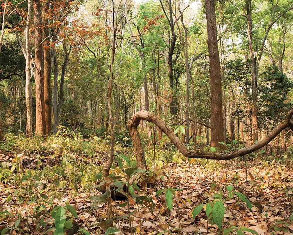
Forests
Monsoon precipitation and land surface temperature over the Indian sub-continent landmass have a significant impact on the distribution of vegetation. In Sikkim, many endemic plant species have migrated to higher elevation in two alpine valleys between the mid-19th century and the present.
Mundra forest on the western coast of Gujarat state is famous for its unique mangrove biodiversity. An analysis of the meteorological variables indicates high pressure and changes in mangrove density during the period of 1994 to 2010. Mundra mangroves are at high risk of climate change- induced habitat loss.
THE decline of subalpine forests and treeline elevation was coincident with weakening monsoonal influence and increasing anthropogenic interferences. Altitudinal movement of temperature sensitive plant species is being observed in the state of Jammu and Kashmir.
Coastal areas and Marine ecosystems
Based on the 5th Assessment Report (AR5) of the Intergovernmental Panel on Climate Change (IPCC), the mean sea level rise in the global ocean was estimated to be about 1.7 [1.5 to 1.9] mm per year between 1901 and 2010, and it increased to 3.2 [2.8 to 3.6] mm per year between 1993 and 2010. Long-term sea level estimates using tide gauge records show a rate of sea level rise of about 1.06-1.75 mm per year in the Indian Ocean during 1878-2004. However, altimeter data analysis over 1993–2012 period reveals that the rate of sea level rise is rather spatially homogeneous over most of the north Indian Ocean, reaching values close to global mean sea level rise trend (3.2 mm per year). This indicates that the rate of sea level rise has accelerated. It is reinforced by a 2017 study which mentions that the sea level rise in the North Indian Ocean has accelerated to 2.3 ± 0.09 mm per year during 1993–2015. Analyses of long-term climate data sets and ocean model sensitivity experiments indicated that significant increase in North Indian Ocean sea level during last three to four decades is accompanied by a weakening of summer monsoon circulation.

The increase in sea surface water temperature (up to 34°C) in the summer of 2010 resulted in bleaching of about 74 per cent to 77 per cent of corals in the South Andaman. Several coral species such as Acropora cerealis, A. humilis, Montiporasp., Favia pallida, Diploastrea sp., Goniopora sp., Gardineroseries sp., Porites sp., were severely affected. The recovery of coral cover observed after bleaching was 21.1 per cent at Port Blair and 13.29 per cent at Havelock Island. The mortality rate of coral cover at Port Blair Bay and Havelock Island was estimated at 2.05 per cent and 9.82 per cent, respectively. Coral bleaching due to thermal stress was also reported in summer months of 2016 along the Andaman coast.
The Government has prepared adaptation- oriented missions under the National Action Plan on Climate Change, recognizing the potential threats of climate change to hydrological systems, ecosystems, sea levels, crop production and other related processes.
Progress on the evidence-based research on systematic observations of impacts
India is a vast country endowed with great variations in climate and vegetation, showing a wide variety of ecosystem types. It is high time to initiate long-term ecological observations in different ecosystems in India to record the long-term large-scale response of ecosystems in the changing environment scenario in the 21st century. Recognizing the need explained above, the science initiatives are planned by the Ministry as part of the Climate Change Action Programme (CCAP). Long Term Ecological Observatories (LTEO) programme is funded and operated through the Climate Change Division at the Ministry of Environment, Forest and Climate Change (MoEFCC), Government of India. As the programme is complex and spread over a large geographical area, the network of scientists involved in the programme would inevitably come from scientific institutions and research groups across the country.
Long Term Ecological Observatories
Long Term Ecological Observatories (LTEO) for climate change studies are one of the components under the ‘Climate Change Action Programme’ with an outlay of INR 40 crore in the 12th Five Year Plan Period. A Science Plan of LTEO was released during the 21st Conference of Parties to the UNFCCC at Paris in December 2015. The first phase of the LTEO Programme includes creating a network of field sites to assess the health of eight different biomes of the country namely; Western Himalaya, Eastern Himalaya, North-Western Arid Zone, Central Indian Forests, Western Ghats, Andaman & Nicobar Islands, Jammu & Kashmir and Sundarbans.
India’s LTEO programme, through a network of scientific institutions, aims to understand the biophysical and anthropogenic drivers of ecosystem change in selected biomes and their impact on social-ecological responses. Activities include experimental work to assess the change of structure and function in the natural ecosystems, identification of patterns and drivers of change in the natural ecosystems by monitoring populations of freshwater fish, birds, mammals, herbivores and carnivores, animal movements, soil processes in forests and grasslands, biophysical climatic variables, etc.
THERE are examples of countries participating in long term ecological research. National Science Foundation of United States has initiated establishing Long Term Ecological Research (LTER) station network since 1980 from 5 sites to collect detailed information on various ecological patterns, processes and phenomena that vary over a long-term and on a large scale to acquire knowledge and predictive understanding that is necessary for the proper management of ecosystems and their services. In 1993, the establishment of International LTER (ILTER) stations was initiated to cover a greater range of ecosystem types over the world and it has become the ‘network of networks’ by joining a total of 39 countries (each having number of LTER stations). About half of the existing networks are located in the European countries having relatively similar climatic conditions and degrees of anthropogenic stress and the remaining half are distributed in North America, South America, Australia, Africa and quite a few in Asian countries like China, Japan, Thailand and Philippines. The ILTER Coordinating Committee, the governing body of the ILTER Network, convenes annually at a meeting hosted by one of the Member Networks.
Indian Network for Climate Change Assessment (INCCA)
To increase capacity at the institutional level for conducting research into Climate Change science and making necessary assessments, MoEFCC has set up an evolving and dynamic network, namely the Indian Network for Climate Change Assessment (INCCA) comprising of 127 research institutions tasked with undertaking research on the science of Climate Change and its impacts on different sectors of economy across various regions of India. INCCA has helped the Ministry put together its Greenhouse Gas (GHG) Emissions Inventories and in carrying out other scientific assessments at more frequent intervals. Efforts need to be made to make INCCA a part of ILTER. This will help to strengthen Indo-US and other international cooperation on climate change. Most ILTER members are national or regional networks of scientists engaged in long-term, site-based ecological and socio-economic research (known as LTER or LTSER). The data gathered from the above-mentioned network can be suitably linked / exchanged with the ongoing ILTER programme. The expansion of LTER network in countries like India would make it possible to represent a greater range of ecosystem types that are being influenced by changes in climate, biogeochemistry and biodiversity.
Coordinated Studies on Climate Change for North East region (CSCCNE)
Another effort in the direction of evidence-based research on Climate Change in India, being steered at the government’s level is the CSCCNE programme under CCAP. The North-eastern region can be physio graphically categorised into the Eastern Himalayas, Northeast Hills (Patkai-Naga Hills and Lushai Hills) and the Brahmaputra and the Barak Valley Plains. The North-eastern region of India is characterized by diverse climate regimes. The region is highly dependent on the southwest monsoon (June–September), with over 60 per cent of the crop area is under rain-fed agriculture, and so is in areas highly vulnerable to climate variability and climate change. The region has two main river basins (the Brahmaputra and Barak), a large dependence of the population on natural resources, and poor infrastructure development. The powerful hydrological and monsoon regime of the region, especially the Brahmaputra and the Barak (Meghna) river system are both a resource and source of vulnerability.
JHUM cultivation, a traditional agricultural system, is often cited as a reason for the loss of the region’s forest cover. This primary agricultural economic activity carried out by local tribes reflects the use of 35 crop varieties. The area is rich in medicinal plants and many rare and endangered taxa. Its high endemism in both higher plants, vertebrates and avian diversity has qualified it as a ‘hotspot’ for biodiversity. In 1995, the International Union for Conservation of Nature identified Namdapha in Arunachal Pradesh as a centre of plant diversity.

The following figures highlight the significance of the region:
- Fifty-one forest types are found in the region broadly classified into six major types — tropical moist deciduous forests, tropical semi- evergreen forests, tropical wet evergreen forests, subtropical forests, temperate forests and alpine forests
- Out of the nine important vegetation types of India, six are found in the North Eastern region
- These forests harbour 8,000 out of 15,000 species of flowering plants. In floral species richness, the highest diversity is reported from the states of Arunachal Pradesh (5000 species) and Sikkim (4500 species) amongst the North Eastern States
- According to the Indian Red data book published by the Botanical Survey of India, 10 per cent of the flowering plants in the country are endangered. Of the 1500 endangered floral species, 800 are reported from North East India
- Most of the North Eastern states have more than 60 per cent of their area under forest cover; a minimum suggested coverage for the hill states in the country
- North East India is a part of Indo-Burma ‘hotspot’. The hotspot is the world’s second largest, next only to the Mediterranean basin with an area 2.2 million sq km. among the 25 identified
- The Eastern Himalaya and the Assam plains have been identified as an Endemic Bird Area by the Royal Society for Protection of Birds.
THE INCCA 4×4 assessment report has made assessments in the national and regional level regarding climate projections and vulnerability. Some of the north-east specific results as extracted from the report are as follows:
- The trend in precipitation in the north-eastern region exhibits considerable spatial variability with respect to the predictions for the 2030s. The northern part shows a reduction in precipitation varying from 3 per cent in the north-western portion to about 12 per cent in the north-eastern portion. In the remaining part of the north-east, there is an increase in precipitation varying up to 25 per cent for the central portion of the north-east. The majority of the north-eastern region, but for some parts of Mizoram, Tripura, Manipur and Assam, shows an increase in evapotranspiration during the 2030s scenario. It is interesting to note that even those parts of Arunachal Pradesh that were showing a decrease in precipitation show an increase in evapotranspiration The trend in water yield in the north-eastern region is similar to the precipitation trend. The areas that have shown less increase in precipitation show a correspondingly low water yield. The reduction in water yield in Arunachal Pradesh is up to about 20 per cent. An increase in water yield is seen in Assam and Manipur and the magnitude is up to about 40 per cent
- The projected increase of night-time temperature may lead to a decrease in the production of rice and hence affect the nutritional health of the population
- Soil erosion due to an increase in the intensity of precipitation events may lead to an increase in the occurrence of landslides, affecting agriculture activities, including tea plantations. This might lead to morbidity among the workforce dependent on this
- Also, there is a likelihood that the windows of transmission of malaria may increasingly remain open for at least for 7–9 and may even remain open for a larger number of months (10–12 months) in a year.
National Mission on Sustaining the Himalayan Ecosystem
There is a serious lack of systematic studies and empirical observations about species-level impacts of climate change in the Himalayas. The main goal of NMSHE is to assess scientifically the vulnerability of the Himalayan region to climate change in physical, biological and socio-cultural context. Major initiatives include the establishment of a Centre for Himalayan Glaciology at the Wadia Institute of Himalayan Ge-ology, Dehradun. Under the mission, State Climate Change Cells (SCCC) in the Himalayan States have been set up. These cells provide support for vulnerability and risk assessment studies at district and sub-district levels as well as for institutional and capacity building. At the state level, a training institute or a university has been designated for conducting the capacity building programmes. A training manual has also been developed following a consultative process. The manual provides information on climate change impacts and risk mitigation and adaptation measures in the Indian Himalayan region.
National Mission on Strategic Knowledge for Climate Change
One of the NAPCC’s mission is on ‘Strategic Knowledge for Climate Change’ which is being coordinated by the Department of Science and Technology, Government of India. The main objectives of this mission are as follows:
- Formation of knowledge networks among the existing knowledge institutions engaged in research and development relating to climate science, and facilitate data sharing and exchange through a suitable policy framework and institutional support
- Establishment of global technology watch groups with institutional capacities to carry out research on risk minimized technology selection for developmental choices
- Development of national capacity for modelling the regional impact of climate change on different ecological zones within the country for different seasons and living standards
- Establishing research networks and encouraging research in the areas of climate change impacts on important socio-economic sectors like agriculture, health, natural ecosystem, biodiversity, coastal zones, etc
- Providing an improved understanding and awareness of the key climate processes and the resultant climate risks and associated consequences
- Building alliances and partnerships through global collaboration in research and technology development on climate change under international and bilateral S&T cooperation arrangements.
Two National Knowledge Networks viz., a Network on Climate Change, Human Health and Climate Modelling have been set up. Two more networks are being launched shortly: Network on Climate Change and Agriculture and a Network on Coastal Vulnerability. Three new National Knowledge Network Programmes were launched in areas including climate modelling, climate change and human health, and climate change and coastal vulnerability.

Alpine Treeline Ecotone
- ISRO has also established a multi-summit approach based on long-term ecological record sites, known as a network of “HIMADRI” (Himalayan Alpine Dynamics Research Initiative) in partnership with subject expert institutions to study changes in the Alpine treeline ecotone due to climate change. This will map species level migration. The archived satellite data (from 1976 to 2014) show that the alpine ecosystem is definitely undergoing changes and alpine treeline has shifted upward with the positive greening trend observed at the alpine treeline ecotone
- The satellite information thus collected will contribute to strengthening the country’s scientific response towards addressing the im-pacts of climate change.
The way forward
The Earth system is complex and long-term policy direction can only be based on long-term observations and comprehensive assessments of the best available science. The UNFCCC calls on Parties to promote and cooperate in research and systematic observation of the climate system, including through exchange of information and supporting international programmes, networks and organizations. Parties are also called upon to cooperate in improving the capacities of developing countries so that they can participate in research and systematic obser-vation activities (Articles 4.1(g,h) and 5). Parties regularly report on their national and cooperative research activities and their contribu-tions to climate science, as well as emerging research needs and priorities through their National Communications. Under the National Communication periodically submitted by the Parties to the UNFCCC, information on National Inventories, Climate Change Vulnerability and adaptation, Mitigation Actions, Research and Systematic Observation and other details are provided. India has already submitted Initial and Second National Communications in 2004 and 2012, respectively.
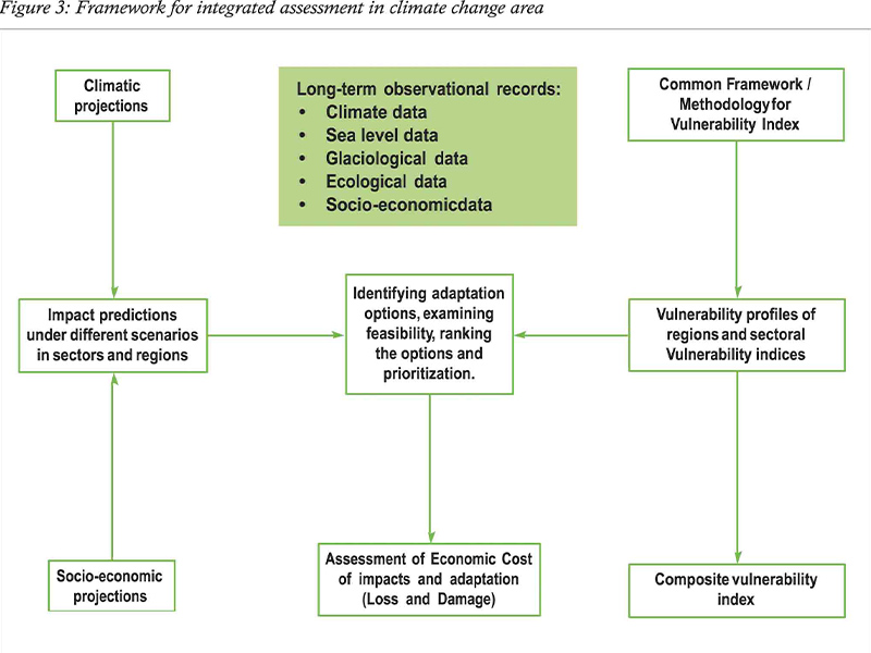
There are certain gaps identified in both the reports in existing knowledge which need to bridge with a better understanding of issues related to climate change. This will require long- term ecological monitoring and research through monitoring stations and/or observatories through a network of institutions. A combination of long- term observation and anticipatory investigations would be helpful in the context of climate change. A schematic diagram of the broad framework discussed in this section is given in Figure 3.
INDIA’S climate variability trends need to be compiled followed by climatic projections using multiple models and impact assessment in different sectors in different climate scenarios. Model ensembles such as CORDEX and CMIP5 may be used for projections. These sectors and regions should be subjected to quantitative assessment of vulnerability by constructing a ‘vulnerability index’ for each sector. The vulnerability index is a key indicator for measuring the vulnerability of a sector/ region. This index may be based on several sets of indicators that assess vulnerability of a region/sector.
Vulnerability indices may be developed for different sectors such as water vulnerability index, agriculture vulnerability index and forest vulnerability index. Vulnerability indices developed at the sub-regional level for different sectors and sub-sectors may be ranked on an ordinal scale. Based on vulnerability indices, GIS-integrated spatial vulnerability profiles and maps need to be prepared. A composite vulnerability index could be developed after integrating all sectoral indices in a scientific manner.
It will serve as a single number, which can be used to compare different regions. Adaptation strategies will be developed based on the identified vulnerability profiles and maps. Vulnerability indices will be calculated in each core sector and a composite index will be estimated for states and for the country as a whole.


